


V - 2019 - 12 & 14-05 La Rochepot Orches

clabidault
User
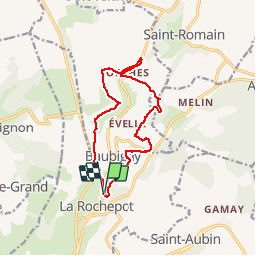

Length
11.9 km

Max alt
563 m

Uphill gradient
427 m
Km-Effort
17.6 km

Min alt
324 m

Downhill gradient
419 m
Boucle
Yes
Creation date :
2018-03-15 00:00:00.0
Updated on :
2019-05-06 20:22:29.624
4h03
Difficulty : Unknown

FREE GPS app for hiking
 SityTrail
IGN / Geographical institutes
SityTrail Plus
The world is yours!
About
Trail Walking of 11.9 km to be discovered at Bourgogne-Franche-Comté, Côte-d'Or, La Rochepot. This trail is proposed by clabidault.
Description
Circuit Evelle, Orches, Dracy,La Rochepot.
Positioning
Country:
France
Region :
Bourgogne-Franche-Comté
Department/Province :
Côte-d'Or
Municipality :
La Rochepot
Location:
Unknown
Start:(Dec)
Start:(UTM)
627860 ; 5202158 (31T) N.
Comments